- ALL COMPUTER, ELECTRONICS AND MECHANICAL COURSES AVAILABLE…. PROJECT GUIDANCE SINCE 2004. FOR FURTHER DETAILS CALL 9443117328
Projects > COMPUTER > 2020 > NON IEEE > APPLICATION
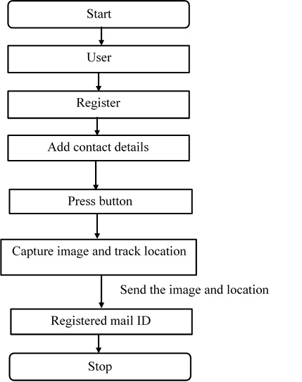
Sangrakshak-Security App is an innovative safety application for women, senior citizens and anyone who needs assistance in an urgent situation. This application is designed to get you help with minimal or unnoticeable efforts. This project presents an alternative approach to the traditional methods. This application will notify friends or family if you are in some trouble and need a help from them. It sends your Android phones location through GPS by using SMS so you can be found fast. In the proposed system, if the user was in the trouble or any accidents occurred then the user press the button of the android mobile. After pressing the button the current location is tracked and the image is captured. Then the notification message will be sent to the contact members already added in the mobile. The notification message contains the details about current position of the mobile user along with the captured image will be send to the registered mobile members contact number and to their E-mail. It provides the more security to the user.
Location based service (LBS) is a mobile service that has the capability to provide real time information based on the users current location. Geographic Information system (GIS) is the heart of location based services, System which has been developed will act as collection centre, storing and supplying the geographical data for being manipulated by the application. Data which stored at the system will be used within making the decision process. Through this application, data will be collected to trace every unit location and every unit also can update any additional information. GIS integrates hardware, software and data for capturing, managing, analyzing and displaying all forms of geographically referenced information. GIS allows us to view, understand, question, interpret and visualize data in many ways that reveal relationships, pattern and trends in the form of globes, maps, charts and reports.
In the proposed system, the user register emergency contact number details and Mail Id. The GPS Coder used this information to search an exact address of that location as the street name, nearby junction etc. If the user was in the trouble or any accidents occurred then the user press the button of the android mobile then the notification message with the location was sent to the police, hospitals and the contact members already added in the mobile. The notification message contains the current position of the mobile user is added with the custom message that had been initially set in the application and is transmitted to the phone registered numbers. After that the automatically camera is going to start and the image will be capture by the user at that moment. Also, the images that was captured during the incident was sent to the registered contacts mail ID. It provides the more security to the user.
Architecture Diagram